
Home >Technology peripherals >AI >Fuya's intelligent drone inspection has been upgraded, with three highlights leading the way in autonomous flight
Fuya's intelligent drone inspection has been upgraded, with three highlights leading the way in autonomous flight

- 王林forward
- 2023-10-24 14:25:011462browse
Recently, Fuya Intelligent Technology has upgraded drone technology, combining cutting-edge technology with practical experience in drone inspection and patrol, and launched a series of professional functions and optimizations. The new features and optimizations this time mainly focus on point of interest query, gas detection mounting adaptation and map album functions. The following is a detailed explanation of these three functions:
1. Point of Interest Flight: Flexibly and quickly empowering urban fixed-point management
In the map interface, users can easily search and query specific points of interest. Furthermore, they can quickly dispatch idle drones at the airport to these target points. During operation, just enter the landmark name or coordinate query, click the "Point to Fly" option, and the system will automatically filter the suitable flight range and airport equipment. Users can also configure relative flight altitude and speed for their missions.
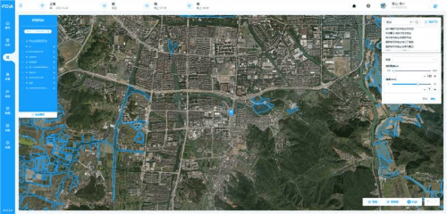
This new function of Fuya’s intelligent drone automatic flight system greatly improves the flexibility and efficiency of flight missions. There is no need to pre-set complicated routes and no special operating skills are required. In order to ensure flight safety, the system presets safe flight parameters, including flight altitude, speed and distance.
This fast point-of-interest flight mode is especially suitable for quick viewing and inspection of specific locations, such as city management, environmental monitoring and campus security. In specific situations such as police receiving alarms, problem alarms and emergency reports, this mode can be used to quickly reach the target point and provide key information for quick decision-making.
2. Gas detection flight: enable real-time detection for environmental monitoring and chemical security
The drone is equipped with a "Lingxiu v2" gas detector. During the drone's patrol inspection flight, it can detect a variety of gas data in real time, including VOCs, PM2.5, etc., and store these data in real time Displayed on the Ruiyun management and control platform. If there is abnormal data, the platform will remind users through pop-up windows, voice or text messages. After the flight is completed, users can also download an offline report of the gas detection.
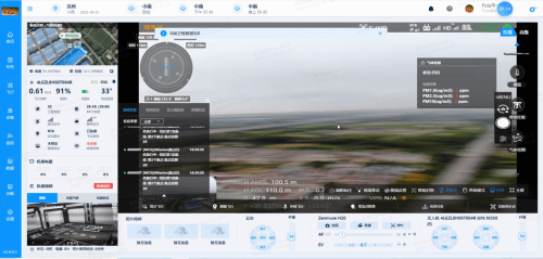
Before starting the task, the user needs to select "Gas Detection" in the task configuration and configure the threshold range of gas detection as needed. During flight, users can monitor gas data in real time and receive relevant alerts.
The gas detection function is particularly suitable for environmental protection, park management and emergency response. This new function of the Fuya intelligent drone automatic flight system can provide decision-makers with accurate on-site gas data and reduce direct exposure to dangerous gases. risk.
3. Map album function: inspection data is more intuitive and analysis is more accurate
Photos are displayed directly on the map/data interface based on the location of the photo point, making it easy to visually check the local situation. Visualize data traceability to obtain richer data and help you understand the situation on the ground more intuitively.
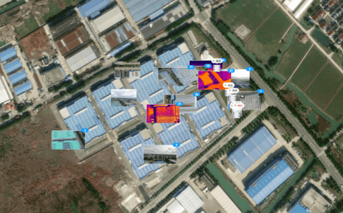
Through this function of Fuya Intelligence, users can view photos at different times at the same place through the timeline function, compare and analyze changes in the place; when a problem is detected somewhere, they can directly locate it on the map and View photos of the location to quickly understand the details of the problem; when making inspection reports or analyzing documents, you can directly insert photos from the map album to make the report more intuitive and complete; the map album function makes it easier to share data with other teams or departments to promote cross-department collaboration.
Fuya Intelligence conducted this update based on the actual combat experience of 500 deployments, aiming to further improve mission flexibility, strengthen the fully automatic operation capability of UAVs, and better serve urban management, environmental protection and emergency response Rescue and other fields, thereby improving the user experience and operational efficiency of drone patrol inspections.
The above is the detailed content of Fuya's intelligent drone inspection has been upgraded, with three highlights leading the way in autonomous flight. For more information, please follow other related articles on the PHP Chinese website!
Related articles
See more- Technology trends to watch in 2023
- How Artificial Intelligence is Bringing New Everyday Work to Data Center Teams
- Can artificial intelligence or automation solve the problem of low energy efficiency in buildings?
- OpenAI co-founder interviewed by Huang Renxun: GPT-4's reasoning capabilities have not yet reached expectations
- Microsoft's Bing surpasses Google in search traffic thanks to OpenAI technology