


Major part of XTools Pro tools can be used in ArcGIS Geoprocessing environment, i.e. they can be run from ArcToolbox or used in the models and scripts. Feature Conversions toolset includes: - Convert Features to Centroids - Convert Feature
Major part of XTools Pro tools can be used in ArcGIS Geoprocessing environment, i.e. they can be run from ArcToolbox or used in the models and scripts.
Feature Conversions toolset includes:
Overlay Operations toolset includes:
Table Operations toolset includes:
Data Management toolset includes:
Surface Tools toolset:
|
![[非官方]ArcGIS10.2 for Desktop扩展工具包XTools Pro](/inc/test.jsp?url=http%3A%2F%2Fwww.xtoolspro.com%2Fimages%2FToolbox101.jpg&refer=http%3A%2F%2Fblog.csdn.net%2Flinghe301%2Farticle%2Fdetails%2F25799037) |
Data Management tools:
![[非官方]ArcGIS10.2 for Desktop扩展工具包XTools Pro](/inc/test.jsp?url=http%3A%2F%2Fwww.xtoolspro.com%2Fimages%2Ftools%2Fdm1.jpg&refer=http%3A%2F%2Fblog.csdn.net%2Flinghe301%2Farticle%2Fdetails%2F25799037)
Create FeatureClass/Table
allows creating new feature classes and stand-alone tables in ArcMap without using ArcCatalog. Resulting feature classes can be stored as shapefiles or personal geodatabase feature classes (new personal geodatabase can be created by this tool if required). While creating new layers, any structure of attribute table can be designed, and any properties can be specified for attribute and shape fields.![[非官方]ArcGIS10.2 for Desktop扩展工具包XTools Pro](/inc/test.jsp?url=http%3A%2F%2Fwww.xtoolspro.com%2Fimages%2Ftools%2Fdm2.jpg&refer=http%3A%2F%2Fblog.csdn.net%2Flinghe301%2Farticle%2Fdetails%2F25799037)
Create File Geodatabase ![[非官方]ArcGIS10.2 for Desktop扩展工具包XTools Pro](/static/imghwm/default1.png)
the tool is provided for creating new file geodatabases directly in ArcGIS ArcMap without using ArcCatalog.![[非官方]ArcGIS10.2 for Desktop扩展工具包XTools Pro](/inc/test.jsp?url=http%3A%2F%2Fwww.xtoolspro.com%2Fimages%2Ffree.jpg&refer=http%3A%2F%2Fblog.csdn.net%2Flinghe301%2Farticle%2Fdetails%2F25799037)
![[非官方]ArcGIS10.2 for Desktop扩展工具包XTools Pro](/inc/test.jsp?url=http%3A%2F%2Fwww.xtoolspro.com%2Fimages%2Ftools%2Fdm3.jpg&refer=http%3A%2F%2Fblog.csdn.net%2Flinghe301%2Farticle%2Fdetails%2F25799037)
Create Personal Geodatabase
this tool is provided for creating new empty personal geodatabases directly in ArcGIS ArcMap without using ArcCatalog. The tool functionality is similar to ArcGIS ArcCatalog "Create new personal geodatabase" functionality.![[非官方]ArcGIS10.2 for Desktop扩展工具包XTools Pro](/inc/test.jsp?url=http%3A%2F%2Fwww.xtoolspro.com%2Fimages%2Ftools%2Fdm4.jpg&refer=http%3A%2F%2Fblog.csdn.net%2Flinghe301%2Farticle%2Fdetails%2F25799037)
Delete Dataset
this tool is aimed to deleting of ArcGIS datasets directly in ArcGIS ArcMap without using ArcCatalog. The tool functionality is similar to ArcGIS ArcCatalog "Delete" functionality. Any of the datasets supported by ArcGIS can be deleted using "Delete Dataset" tool.![[非官方]ArcGIS10.2 for Desktop扩展工具包XTools Pro](/inc/test.jsp?url=http%3A%2F%2Fwww.xtoolspro.com%2Fimages%2Ftools%2Fdm5.jpg&refer=http%3A%2F%2Fblog.csdn.net%2Flinghe301%2Farticle%2Fdetails%2F25799037)
Change Datasources
allows fixing broken or changed links to data sources in the map documents.![[非官方]ArcGIS10.2 for Desktop扩展工具包XTools Pro](/inc/test.jsp?url=http%3A%2F%2Fwww.xtoolspro.com%2Fimages%2Ftools%2Fdm6.jpg&refer=http%3A%2F%2Fblog.csdn.net%2Flinghe301%2Farticle%2Fdetails%2F25799037)
Create Random Sampling Points
creates new randomly spread sampling points, various constraining conditions can be applied.![[非官方]ArcGIS10.2 for Desktop扩展工具包XTools Pro](/inc/test.jsp?url=http%3A%2F%2Fwww.xtoolspro.com%2Fimages%2Ftools%2Fdm7.jpg&refer=http%3A%2F%2Fblog.csdn.net%2Flinghe301%2Farticle%2Fdetails%2F25799037)
MultiRename Datasets
renames multiple datasets at once using various advanced and flexible renaming masks and options.Feature Conversions:
![[非官方]ArcGIS10.2 for Desktop扩展工具包XTools Pro](/inc/test.jsp?url=http%3A%2F%2Fwww.xtoolspro.com%2Fimages%2Ftools%2Ffc1.jpg&refer=http%3A%2F%2Fblog.csdn.net%2Flinghe301%2Farticle%2Fdetails%2F25799037)
Transfer/Convert Features
provides an easy way to copy selected spatial features from one layer and paste them into another layer. This command cannot be used to build features that are more complex than the source features. This means that you cannot use this command to build Polylines from Points, Polygons from Polylines or Points, etc. Such operations are beyond the scope of this command.![[非官方]ArcGIS10.2 for Desktop扩展工具包XTools Pro](/inc/test.jsp?url=http%3A%2F%2Fwww.xtoolspro.com%2Fimages%2Ftools%2Ffc2.jpg&refer=http%3A%2F%2Fblog.csdn.net%2Flinghe301%2Farticle%2Fdetails%2F25799037)
Convert Multipart Shapes to Single Parts
converts selected multipart shapes to single part shapes and stores them in a new shapefile. If no shapes are currently selected, all shapes in layer will be processed. Source shapes can be single part, multi-part or mixed in the layer. The output shapefile attribute table will contain the same fields as the input layer attribute table.This tool requires that there is at least one feature layer in the Data Frame.
----------------------------------------------------------------------------------
Blog: http://blog.csdn.net/linghe301
----------------------------------------------------------------------------------
![[非官方]ArcGIS10.2 for Desktop扩展工具包XTools Pro](/inc/test.jsp?url=http%3A%2F%2Fwww.xtoolspro.com%2Fimages%2Ftools%2Ffc3.jpg&refer=http%3A%2F%2Fblog.csdn.net%2Flinghe301%2Farticle%2Fdetails%2F25799037)
Convert Polygons to Polylines
converts selected polygons to single part polylines and stores them in a new shapefile. If no polygons are currently selected, all polygons in the layer are processed. Source polygons can be single part, multi-part or mixed in the layer. The output polyline attribute table will contain the same fields as one of the input polygons.![[非官方]ArcGIS10.2 for Desktop扩展工具包XTools Pro](/inc/test.jsp?url=http%3A%2F%2Fwww.xtoolspro.com%2Fimages%2Ftools%2Ffc4.jpg&refer=http%3A%2F%2Fblog.csdn.net%2Flinghe301%2Farticle%2Fdetails%2F25799037)
Convert Features to Points
provides ArcGIS users with capabilities to convert polygon and polyline features to points with customizable options.![[非官方]ArcGIS10.2 for Desktop扩展工具包XTools Pro](/inc/test.jsp?url=http%3A%2F%2Fwww.xtoolspro.com%2Fimages%2Ftools%2Ffc5.jpg&refer=http%3A%2F%2Fblog.csdn.net%2Flinghe301%2Farticle%2Fdetails%2F25799037)
Make Polygons from Polylines
converts selected polyline features of a layer into single part polygon(s), and stores them a new shapefile. If no polylines are currently selected, all the polylines in the layer will be processed. The polylines do not need to be snapped together. Gaps between polylines will be bridged with a straight line. Source polylines can be single part, multi-part or mixed in the layer. Neither the order of the polylines in the Feature Table, nor the order in which the polylines are selected is important.If polylines from more than one layer will be used to build the polygon, the user will need to assemble the necessary polylines in a separate layer before running this command. A common example of this situation is the necessity to build a polygon from lines borrowed from PLS, Roads, Streams ... layers. If there are gaps between the source polylines that should not be bridged with a straight line, the user should digitize in polylines to fill the gaps prior to running the command. This command differs from the ArcInfo Build command (polygon option) in that only one polygon can be built in a single operation.
![[非官方]ArcGIS10.2 for Desktop扩展工具包XTools Pro](/inc/test.jsp?url=http%3A%2F%2Fwww.xtoolspro.com%2Fimages%2Ftools%2Ffc6.jpg&refer=http%3A%2F%2Fblog.csdn.net%2Flinghe301%2Farticle%2Fdetails%2F25799037)
Make Polygons from Points
converts point features of a point layer to single part polygon(s) and stores them in a new shapefile or personal geodatabase feature class.This command differs from the Arc/INFO Build command (polygon option) in that only one polygon can be built in a single operation. Also, no intersecting or cleaning is done, so the user must do the equivalent preparatory work (if necessary) prior to using the command in order to get the appropriate results.
Note: Multipoint layers are not supported in this tool!
![[非官方]ArcGIS10.2 for Desktop扩展工具包XTools Pro](/inc/test.jsp?url=http%3A%2F%2Fwww.xtoolspro.com%2Fimages%2Ftools%2Ffc7.jpg&refer=http%3A%2F%2Fblog.csdn.net%2Flinghe301%2Farticle%2Fdetails%2F25799037)
Make Polylines from Points
converts a point layer to polyline(s), and stores them in a new shapefile or personal geodatabase feature class.This command differs from the Arc/INFO Build command (arc option) in that only one line can be built in a single operation. Also, no intersecting or cleaning is done, so the user must do the equivalent preparatory work (if necessary) in advance of using the command in order to get the desired results.
![[非官方]ArcGIS10.2 for Desktop扩展工具包XTools Pro](/inc/test.jsp?url=http%3A%2F%2Fwww.xtoolspro.com%2Fimages%2Ftools%2Ffc8.jpg&refer=http%3A%2F%2Fblog.csdn.net%2Flinghe301%2Farticle%2Fdetails%2F25799037)
Convert Graphics to Shapes
creates one shapefile for each user-selected shape type (graphics) in the ArcMap Data View. Rectangle, circle and polygon graphics are converted to polygon shapes. Line and polyline graphics are converted to polyline shapes. Point graphics are converted to point shapes.![[非官方]ArcGIS10.2 for Desktop扩展工具包XTools Pro](/inc/test.jsp?url=http%3A%2F%2Fwww.xtoolspro.com%2Fimages%2Ftools%2Ffc9.jpg&refer=http%3A%2F%2Fblog.csdn.net%2Flinghe301%2Farticle%2Fdetails%2F25799037)
Shapes to Centroids
creates a new point shape file from the center points (centroids) of the shapes in the input shapefile. A centroid of a shape is the spatial location of its "center of mass". Attribute fields in the input layer are transferred to the output shapefile.----------------------------------------------------------------------------------
Blog: http://blog.csdn.net/linghe301
----------------------------------------------------------------------------------
![[非官方]ArcGIS10.2 for Desktop扩展工具包XTools Pro](/inc/test.jsp?url=http%3A%2F%2Fwww.xtoolspro.com%2Fimages%2Ftools%2Ffc10.jpg&refer=http%3A%2F%2Fblog.csdn.net%2Flinghe301%2Farticle%2Fdetails%2F25799037)
Split Polylines
provides ArcGIS users with capabilities to split polyline features into separate segments in various customizable ways.![[非官方]ArcGIS10.2 for Desktop扩展工具包XTools Pro](/inc/test.jsp?url=http%3A%2F%2Fwww.xtoolspro.com%2Fimages%2Ftools%2Ffc11.jpg&refer=http%3A%2F%2Fblog.csdn.net%2Flinghe301%2Farticle%2Fdetails%2F25799037)
Split Polygons
provides capabilities for advanced splitting of polygon features.![[非官方]ArcGIS10.2 for Desktop扩展工具包XTools Pro](/inc/test.jsp?url=http%3A%2F%2Fwww.xtoolspro.com%2Fimages%2Ftools%2Ffc12.jpg&refer=http%3A%2F%2Fblog.csdn.net%2Flinghe301%2Farticle%2Fdetails%2F25799037)
Smooth Polylines
smoothes input polyline features using Bezier or B-splines.![[非官方]ArcGIS10.2 for Desktop扩展工具包XTools Pro](/inc/test.jsp?url=http%3A%2F%2Fwww.xtoolspro.com%2Fimages%2Ftools%2Ffc13.jpg&refer=http%3A%2F%2Fblog.csdn.net%2Flinghe301%2Farticle%2Fdetails%2F25799037)
Split Layer by Attributes
splits layers into separate datasets by one or more attributes.![[非官方]ArcGIS10.2 for Desktop扩展工具包XTools Pro](/inc/test.jsp?url=http%3A%2F%2Fwww.xtoolspro.com%2Fimages%2Ftools%2Ffc14.jpg&refer=http%3A%2F%2Fblog.csdn.net%2Flinghe301%2Farticle%2Fdetails%2F25799037)
Find Multipart Features
allows searching for multipart features and optionally selecting found multipart features, zooming to them or adding number of parts to the attribute table.Layer Operations:
![[非官方]ArcGIS10.2 for Desktop扩展工具包XTools Pro](/inc/test.jsp?url=http%3A%2F%2Fwww.xtoolspro.com%2Fimages%2Ftools%2Flo1.jpg&refer=http%3A%2F%2Fblog.csdn.net%2Flinghe301%2Farticle%2Fdetails%2F25799037)
Create Interdiv Points
creates interdiv points (polyline and polygon layers supported).![[非官方]ArcGIS10.2 for Desktop扩展工具包XTools Pro](/inc/test.jsp?url=http%3A%2F%2Fwww.xtoolspro.com%2Fimages%2Ftools%2Flo2.jpg&refer=http%3A%2F%2Fblog.csdn.net%2Flinghe301%2Farticle%2Fdetails%2F25799037)
Erase Features
creates a new layer by overlaying two feature layers. The polygons of the erase layer define the erasing region. Input layer features that are within the erasing region are removed. The output layer contains only those input layer features that are outside the erasing region.Input layer features can be polygons, polylines, multipoints or points; erase layer features must be polygons. The output layer features are of the same class as the input layer features. They are clipped to the outer boundary of the erase layer polygons. The attribute table for the output layer contains the same items as the input layer feature attribute table.
----------------------------------------------------------------------------------
Blog: http://blog.csdn.net/linghe301
----------------------------------------------------------------------------------
![[非官方]ArcGIS10.2 for Desktop扩展工具包XTools Pro](/inc/test.jsp?url=http%3A%2F%2Fwww.xtoolspro.com%2Fimages%2Ftools%2Flo3.jpg&refer=http%3A%2F%2Fblog.csdn.net%2Flinghe301%2Farticle%2Fdetails%2F25799037)
Identity
creates a new layer by overlaying two feature layers.The output layer contains all of the input layer features, and only those portions of the overlay layer features that overlap the input layer. The input layer features can be points, polylines, or polygons. The overlay layer features must be polygons. The output layer features resulting from the overlay are of the same class as the input layer features. The feature tables are also updated. The feature table for the output layer contains all the selected fields from the input and overlay layer feature tables. Selecting only the fields that you need in the output significantly speeds up processing.
![[非官方]ArcGIS10.2 for Desktop扩展工具包XTools Pro](/inc/test.jsp?url=http%3A%2F%2Fwww.xtoolspro.com%2Fimages%2Ftools%2Flo4.jpg&refer=http%3A%2F%2Fblog.csdn.net%2Flinghe301%2Farticle%2Fdetails%2F25799037)
Update Polygon Layer
creates a new layer by overlaying two feature layers. The features of the overlay layer define the updating extent. UPDATE uses the updating extent in a "cut-and-paste" operation; the overlay layer features replace the area they overlap in the input layer. The result is stored in the output layer. Both the input and overlay layers must be polygons.UPDATE is one of the three overlay operations available in XTools Pro. ERASE is similar to UPDATE, except that the input layer features which overlap the updating extent are erased instead of updated. ERASE can also be used with polyline and point features.
Table Operations:
![[非官方]ArcGIS10.2 for Desktop扩展工具包XTools Pro](/inc/test.jsp?url=http%3A%2F%2Fwww.xtoolspro.com%2Fimages%2Ftools%2Fto1.jpg&refer=http%3A%2F%2Fblog.csdn.net%2Flinghe301%2Farticle%2Fdetails%2F25799037)
Calculate Geometry
calculates perimeter and area values (including hectares and acres units) for polygon layers and length for polyline layers.After some calculation corresponding fields will be added to the attribute table of the selected layer and populated with values. If such fields already exist in the attribute table, their values can be recalculated and rewritten in the table.
The "Calculate" tool allows:
- choosing a polygon or polyline layer to be measured
- changing projection in which the output parameters values will be calculated
- specifying attributes that are to be calculated: length for polyline features; perimeter, area, acres, hectares for polygon features
naming the attributes to be calculated
Note: The functionality of this tool is only available if there is at least one polygon or polyline layer added in the TOC window.
----------------------------------------------------------------------------------
Blog: http://blog.csdn.net/linghe301
----------------------------------------------------------------------------------
![[非官方]ArcGIS10.2 for Desktop扩展工具包XTools Pro](/inc/test.jsp?url=http%3A%2F%2Fwww.xtoolspro.com%2Fimages%2Ftools%2Fto2.jpg&refer=http%3A%2F%2Fblog.csdn.net%2Flinghe301%2Farticle%2Fdetails%2F25799037)
Add X, Y, Z Coordinates
adds X, Y, and Z coordinates to attribute tables of point, polyline and polygon layers.At that there are options to add Z coordinate for 3D shapes only, specify required coordinate system for output coordinates, and convert angular coordinate units to DMS format.
For point layers this tool adds X or\and Y or\and Z coordinates for all features to the attribute table of this layer.
For polygon layers this tool adds X_Centroid or\and Y_ Centroid or\and Z_ Centroid coordinates for all features to the attribute table of this layer.
For polyline layers this tool adds X or\and Y or\and Z coordinates of the user-defined polyline point for all features to the attribute table of the layer. For polylines coordinates of the FROM, TO, or Center point can be added.Z (or Z_ Centroid) coordinate can be added for 3D shapes only if the corresponding option is selected.
![[非官方]ArcGIS10.2 for Desktop扩展工具包XTools Pro](/inc/test.jsp?url=http%3A%2F%2Fwww.xtoolspro.com%2Fimages%2Ftools%2Fto3.jpg&refer=http%3A%2F%2Fblog.csdn.net%2Flinghe301%2Farticle%2Fdetails%2F25799037)
Aggregate Features/Records
with this tool the user can aggregate features and records on the basis of specified Group By field(s). Various options for the output aggregation geometry type and aggregation function are provided. Results can be stored as a new shapefile, personal geodatabase feature class, stand-alone table or just viewed in ArcMap without saving.![[非官方]ArcGIS10.2 for Desktop扩展工具包XTools Pro](/inc/test.jsp?url=http%3A%2F%2Fwww.xtoolspro.com%2Fimages%2Ftools%2Fto4.jpg&refer=http%3A%2F%2Fblog.csdn.net%2Flinghe301%2Farticle%2Fdetails%2F25799037)
Table Restructure
any kind of modifications can be performed for attribute tables with "Table Restructure" tool. That is, the user can add, move, or remove attribute fields and change their properties. For string fields capitalization can be modified. Results can be stored as a new shapefile, personal geodatabase feature class or stand-alone table (if no shape field is presented). The coordinate system can be modified as well. Besides, there are options for concatenating tables and building spatial indexes for shapefiles.----------------------------------------------------------------------------------
Blog: http://blog.csdn.net/linghe301
----------------------------------------------------------------------------------
![[非官方]ArcGIS10.2 for Desktop扩展工具包XTools Pro](/inc/test.jsp?url=http%3A%2F%2Fwww.xtoolspro.com%2Fimages%2Ftools%2Fto5.jpg&refer=http%3A%2F%2Fblog.csdn.net%2Flinghe301%2Farticle%2Fdetails%2F25799037)
Export Table to MS Excel
allows exporting an attribute table into MS Excel application.This tool starts Excel, creates a "link" between ArcMap and Excel, and copies specified fields and selected rows from an ArcMap Table to an Excel spreadsheet.
In the current version it is possible to save string fields' format during the transferring to Excel. It means that if you have formatted numbers as string values, they will not be automatically converted to Excel number cells. Their formatting will be saved. Exporting to to .xlsx files is also supported.
![[非官方]ArcGIS10.2 for Desktop扩展工具包XTools Pro](/inc/test.jsp?url=http%3A%2F%2Fwww.xtoolspro.com%2Fimages%2Ftools%2Fto6.jpg&refer=http%3A%2F%2Fblog.csdn.net%2Flinghe301%2Farticle%2Fdetails%2F25799037)
MultiDelete Fields
allows deleting multiple attribute fields at a time. This tool gives the user a list of fields to select from and then deletes the selected fields.WARNING: this command acts directly on the active table, not on a copy. A delete confirmation routine is included, but once confirmed all deletion requests are final.
![[非官方]ArcGIS10.2 for Desktop扩展工具包XTools Pro](/inc/test.jsp?url=http%3A%2F%2Fwww.xtoolspro.com%2Fimages%2Ftools%2Fto7.jpg&refer=http%3A%2F%2Fblog.csdn.net%2Flinghe301%2Farticle%2Fdetails%2F25799037)
Table Statistics
analyses a feature table and calculates statistics for each numeric field. The resulting information is written to a new table created by the tool.For every field, the table contains the following information: field name, alias, type, width, decimals, whether or not it is editable and visible.
For numeric fields, the table contains the following statistics: sum, count, mean, min, max, range, variance, and standard deviation.
![[非官方]ArcGIS10.2 for Desktop扩展工具包XTools Pro](/inc/test.jsp?url=http%3A%2F%2Fwww.xtoolspro.com%2Fimages%2Ftools%2Fto8.jpg&refer=http%3A%2F%2Fblog.csdn.net%2Flinghe301%2Farticle%2Fdetails%2F25799037)
Export Table to Text
this tool allows exporting attribute tables or standalone tables to CSV text files. At that, it is possible to export only selected fields and rows of the table. Exported fields in the resulting text file are delimited with comma.![[非官方]ArcGIS10.2 for Desktop扩展工具包XTools Pro](/inc/test.jsp?url=http%3A%2F%2Fwww.xtoolspro.com%2Fimages%2Ftools%2Fto9.jpg&refer=http%3A%2F%2Fblog.csdn.net%2Flinghe301%2Farticle%2Fdetails%2F25799037)
Export Table to HTML
exports attribute tables to HTML format.![[非官方]ArcGIS10.2 for Desktop扩展工具包XTools Pro](/inc/test.jsp?url=http%3A%2F%2Fwww.xtoolspro.com%2Fimages%2Ftools%2Fto10.jpg&refer=http%3A%2F%2Fblog.csdn.net%2Flinghe301%2Farticle%2Fdetails%2F25799037)
Find Duplicates
allows finding and indexing duplicated features/records in feature classes/tables.----------------------------------------------------------------------------------
Blog: http://blog.csdn.net/linghe301
----------------------------------------------------------------------------------
![[非官方]ArcGIS10.2 for Desktop扩展工具包XTools Pro](/inc/test.jsp?url=http%3A%2F%2Fwww.xtoolspro.com%2Fimages%2Ftools%2Fto11.jpg&refer=http%3A%2F%2Fblog.csdn.net%2Flinghe301%2Farticle%2Fdetails%2F25799037)
Sort Features/Records
allows sorting of features/records in feature classes/tables; sorted output is written to a new feature class/table.![[非官方]ArcGIS10.2 for Desktop扩展工具包XTools Pro](/inc/test.jsp?url=http%3A%2F%2Fwww.xtoolspro.com%2Fimages%2Ftools%2Fto12.jpg&refer=http%3A%2F%2Fblog.csdn.net%2Flinghe301%2Farticle%2Fdetails%2F25799037)
Edit with MS Excel
allows editing tables in ArcGIS with Microsoft Excel.![[非官方]ArcGIS10.2 for Desktop扩展工具包XTools Pro](/inc/test.jsp?url=http%3A%2F%2Fwww.xtoolspro.com%2Fimages%2Ftools%2Fto13.jpg&refer=http%3A%2F%2Fblog.csdn.net%2Flinghe301%2Farticle%2Fdetails%2F25799037)
Import Edits from MS Excel
imports edits made in Excel back to ArcMap, requires open edit session for the edited layer/table.Surface Tools:
![[非官方]ArcGIS10.2 for Desktop扩展工具包XTools Pro](/inc/test.jsp?url=http%3A%2F%2Fwww.xtoolspro.com%2Fimages%2Ftools%2Fs1_1.jpg&refer=http%3A%2F%2Fblog.csdn.net%2Flinghe301%2Farticle%2Fdetails%2F25799037)
![[非官方]ArcGIS10.2 for Desktop扩展工具包XTools Pro](/inc/test.jsp?url=http%3A%2F%2Fwww.xtoolspro.com%2Fimages%2Ftools%2Fs1_2.jpg&refer=http%3A%2F%2Fblog.csdn.net%2Flinghe301%2Farticle%2Fdetails%2F25799037)
Create Grid from Contours
Convert Grid to Contour
these two surface tools allow to generate contour polylines from specified grids and vice versa without using ArcGIS 3D Analyst or Spatial Analyst. Grid output format can be ESRI GRID, TIFF, or ERDAS IMAGINE.![[非官方]ArcGIS10.2 for Desktop扩展工具包XTools Pro](/inc/test.jsp?url=http%3A%2F%2Fwww.xtoolspro.com%2Fimages%2Ftools%2Fs2.jpg&refer=http%3A%2F%2Fblog.csdn.net%2Flinghe301%2Farticle%2Fdetails%2F25799037)
Create Grid from Points
interpolates Grids from input points using spline algorithms.![[非官方]ArcGIS10.2 for Desktop扩展工具包XTools Pro](/inc/test.jsp?url=http%3A%2F%2Fwww.xtoolspro.com%2Fimages%2Ftools%2Fs3.jpg&refer=http%3A%2F%2Fblog.csdn.net%2Flinghe301%2Farticle%2Fdetails%2F25799037)
Extract Raster Values
extracts raster (e.g. DEM GRIDs) values to points attributes.![[非官方]ArcGIS10.2 for Desktop扩展工具包XTools Pro](/inc/test.jsp?url=http%3A%2F%2Fwww.xtoolspro.com%2Fimages%2Ftools%2Fs4.jpg&refer=http%3A%2F%2Fblog.csdn.net%2Flinghe301%2Farticle%2Fdetails%2F25799037)
Build Thiessen Polygons
creates Thiessen polygons from input points.![[非官方]ArcGIS10.2 for Desktop扩展工具包XTools Pro](/inc/test.jsp?url=http%3A%2F%2Fwww.xtoolspro.com%2Fimages%2Ftools%2Fs5.jpg&refer=http%3A%2F%2Fblog.csdn.net%2Flinghe301%2Farticle%2Fdetails%2F25799037)
Extract Raster Zonal Statistics
extracts statistics from rasters at the selected polygon zones.----------------------------------------------------------------------------------
Blog: http://blog.csdn.net/linghe301
----------------------------------------------------------------------------------
Go To tools:
![[非官方]ArcGIS10.2 for Desktop扩展工具包XTools Pro](/inc/test.jsp?url=http%3A%2F%2Fwww.xtoolspro.com%2Fimages%2Ftools%2Fgt1.jpg&refer=http%3A%2F%2Fblog.csdn.net%2Flinghe301%2Farticle%2Fdetails%2F25799037)
Go to Google Maps
allows viewing current ArcGIS map location in Google Maps online.![[非官方]ArcGIS10.2 for Desktop扩展工具包XTools Pro](/inc/test.jsp?url=http%3A%2F%2Fwww.xtoolspro.com%2Fimages%2Ftools%2Fgt2.jpg&refer=http%3A%2F%2Fblog.csdn.net%2Flinghe301%2Farticle%2Fdetails%2F25799037)
Go to Google Earth
allows viewing current ArcGIS map location in Google Earth.![[非官方]ArcGIS10.2 for Desktop扩展工具包XTools Pro](/inc/test.jsp?url=http%3A%2F%2Fwww.xtoolspro.com%2Fimages%2Ftools%2Fgt3.jpg&refer=http%3A%2F%2Fblog.csdn.net%2Flinghe301%2Farticle%2Fdetails%2F25799037)
Go to Microsoft Bing Maps
allows viewing current ArcGIS map location in Microsoft Bing Maps online.![[非官方]ArcGIS10.2 for Desktop扩展工具包XTools Pro](/inc/test.jsp?url=http%3A%2F%2Fwww.xtoolspro.com%2Fimages%2Ftools%2Fgt4.jpg&refer=http%3A%2F%2Fblog.csdn.net%2Flinghe301%2Farticle%2Fdetails%2F25799037)
Go to ArcGIS Exlporer
allows viewing current ArcGIS map location in ArcGIS Explorer application.![[非官方]ArcGIS10.2 for Desktop扩展工具包XTools Pro](/inc/test.jsp?url=http%3A%2F%2Fwww.xtoolspro.com%2Fimages%2Ftools%2Fgt5.jpg&refer=http%3A%2F%2Fblog.csdn.net%2Flinghe301%2Farticle%2Fdetails%2F25799037)
Go to OpenStreetMap
allows viewing current ArcGIS map location in the OpenStreetMap online service.Miscellaneous general usage tools:
![[非官方]ArcGIS10.2 for Desktop扩展工具包XTools Pro](/inc/test.jsp?url=http%3A%2F%2Fwww.xtoolspro.com%2Fimages%2Ftools%2Fgu1.jpg&refer=http%3A%2F%2Fblog.csdn.net%2Flinghe301%2Farticle%2Fdetails%2F25799037)
Open Attribute Table button
this button provides prompt and convenient access to the attribute table of a selected layer. Being placed on the XTools Pro toolbar, the button allows opening the attribute table with just one click, which is very habitual for all the ArcView GIS 3.x users.![[非官方]ArcGIS10.2 for Desktop扩展工具包XTools Pro](/inc/test.jsp?url=http%3A%2F%2Fwww.xtoolspro.com%2Fimages%2Ftools%2Fgu2_1.jpg&refer=http%3A%2F%2Fblog.csdn.net%2Flinghe301%2Farticle%2Fdetails%2F25799037)
![[非官方]ArcGIS10.2 for Desktop扩展工具包XTools Pro](/inc/test.jsp?url=http%3A%2F%2Fwww.xtoolspro.com%2Fimages%2Ftools%2Fgu2_2.jpg&refer=http%3A%2F%2Fblog.csdn.net%2Flinghe301%2Farticle%2Fdetails%2F25799037)
Attribute Table Views
provide extended and enriched attribute table windows in ArcMap.![[非官方]ArcGIS10.2 for Desktop扩展工具包XTools Pro](/inc/test.jsp?url=http%3A%2F%2Fwww.xtoolspro.com%2Fimages%2Ftools%2Fgu3.jpg&refer=http%3A%2F%2Fblog.csdn.net%2Flinghe301%2Farticle%2Fdetails%2F25799037)
Smart Add Data
alternative dialog for adding data in ArcMap. In addition to the standard Add Data dialog it allows to filter datasets by datasets name, type, format, geometry type etc., allows to prescribe a number of tasks for the selected dataset and adds a virtual Recent Datasets folder.----------------------------------------------------------------------------------
Blog: http://blog.csdn.net/linghe301
----------------------------------------------------------------------------------
![[非官方]ArcGIS10.2 for Desktop扩展工具包XTools Pro](/inc/test.jsp?url=http%3A%2F%2Fwww.xtoolspro.com%2Fimages%2Ftools%2Fgu4.jpg&refer=http%3A%2F%2Fblog.csdn.net%2Flinghe301%2Farticle%2Fdetails%2F25799037)
Show Nodes
this simple but effective tool will show you all the nodes and vertices in your layers with just one click. Nodes are represented as graphics and can be removed by refreshing data view or any operation that causes re-drawing in the data view.![[非官方]ArcGIS10.2 for Desktop扩展工具包XTools Pro](/inc/test.jsp?url=http%3A%2F%2Fwww.xtoolspro.com%2Fimages%2Ftools%2Fgu5.jpg&refer=http%3A%2F%2Fblog.csdn.net%2Flinghe301%2Farticle%2Fdetails%2F25799037)
Convex Hull
with this tool the user can build convex or detailed hulls either for point, polyline, and polygon layers or for selected features in the layers. As an option hulls can be built for feature groups defined by specified attribute field. Besides buffers can be defined for resulting hulls.![[非官方]ArcGIS10.2 for Desktop扩展工具包XTools Pro](/inc/test.jsp?url=http%3A%2F%2Fwww.xtoolspro.com%2Fimages%2Ftools%2Fgu6.jpg&refer=http%3A%2F%2Fblog.csdn.net%2Flinghe301%2Farticle%2Fdetails%2F25799037)
Extract Map
this revolutionary tool provides ArcGIS users with capabilities to extract any area of the map. Extracted map preserves all the rendering and classification properties and can be stored either in personal geodatabase format or as shapefiles. Extraction boundaries can be defined in many different ways: by current extent, by selected polygon feature in a layer, or by user specified graphics. Tool options include creating shapefile spatial indexes and enabling/disabling clipping features in the process of extraction.![[非官方]ArcGIS10.2 for Desktop扩展工具包XTools Pro](/inc/test.jsp?url=http%3A%2F%2Fwww.xtoolspro.com%2Fimages%2Ftools%2Fgu7.jpg&refer=http%3A%2F%2Fblog.csdn.net%2Flinghe301%2Farticle%2Fdetails%2F25799037)
Create Fishnet
allows to create fishnet feature classes. Created fishnets can be stored as polygons or polylines.![[非官方]ArcGIS10.2 for Desktop扩展工具包XTools Pro](/inc/test.jsp?url=http%3A%2F%2Fwww.xtoolspro.com%2Fimages%2Ftools%2Fgu8.jpg&refer=http%3A%2F%2Fblog.csdn.net%2Flinghe301%2Farticle%2Fdetails%2F25799037)
Identify Pro
in addition to standard ArcMap Identify functionality XTools Pro Identify Pro tool allows to edit attributes and view field types and geometry properties of the identified features.![[非官方]ArcGIS10.2 for Desktop扩展工具包XTools Pro](/inc/test.jsp?url=http%3A%2F%2Fwww.xtoolspro.com%2Fimages%2Ftools%2Fgu9.jpg&refer=http%3A%2F%2Fblog.csdn.net%2Flinghe301%2Farticle%2Fdetails%2F25799037)
Feature Report
allows creating reports on the selected feature(s). Feature reports display feature geometry and include attribute and geometry information derived from the selected feature(s). Created reports can be modified, printed or exported to MS Word application for editing or distribution purposes. This is an additional alternate way for creating reports in ArcGIS.![[非官方]ArcGIS10.2 for Desktop扩展工具包XTools Pro](/inc/test.jsp?url=http%3A%2F%2Fwww.xtoolspro.com%2Fimages%2Ftools%2Fgu10.jpg&refer=http%3A%2F%2Fblog.csdn.net%2Flinghe301%2Farticle%2Fdetails%2F25799037)
----------------------------------------------------------------------------------
Blog: http://blog.csdn.net/linghe301
----------------------------------------------------------------------------------
Start Editing Selected Layer
this button provides prompt and convenient way to start edit session for the selected layer. Having this button on the XTools Pro toolbar you are just one click away from starting editing your data.![[非官方]ArcGIS10.2 for Desktop扩展工具包XTools Pro](/inc/test.jsp?url=http%3A%2F%2Fwww.xtoolspro.com%2Fimages%2Ftools%2Fgu11.jpg&refer=http%3A%2F%2Fblog.csdn.net%2Flinghe301%2Farticle%2Fdetails%2F25799037)
Show Directions
this tool is provided for displaying directions of polyline and polygon features. Directions are displayed with arrow graphic objects and are fixed in the map until switched off.![[非官方]ArcGIS10.2 for Desktop扩展工具包XTools Pro](/inc/test.jsp?url=http%3A%2F%2Fwww.xtoolspro.com%2Fimages%2Ftools%2Fgu12.jpg&refer=http%3A%2F%2Fblog.csdn.net%2Flinghe301%2Farticle%2Fdetails%2F25799037)
Export Data to KML
converts data from ArcGIS to KML/KMZ format for use with Google Earth, for example.![[非官方]ArcGIS10.2 for Desktop扩展工具包XTools Pro](/inc/test.jsp?url=http%3A%2F%2Fwww.xtoolspro.com%2Fimages%2Ftools%2Fgu13.jpg&refer=http%3A%2F%2Fblog.csdn.net%2Flinghe301%2Farticle%2Fdetails%2F25799037)
Find Associated Documents and Datasets
allows to search for map documents associated with the selected dataset or datasets used in the selected map document.![[非官方]ArcGIS10.2 for Desktop扩展工具包XTools Pro](/inc/test.jsp?url=http%3A%2F%2Fwww.xtoolspro.com%2Fimages%2Ftools%2Fgu14.jpg&refer=http%3A%2F%2Fblog.csdn.net%2Flinghe301%2Farticle%2Fdetails%2F25799037)
Auto Save MXD
auto saves backup copies of .mxd map documents.![[非官方]ArcGIS10.2 for Desktop扩展工具包XTools Pro](/inc/test.jsp?url=http%3A%2F%2Fwww.xtoolspro.com%2Fimages%2Ftools%2Fgu15.jpg&refer=http%3A%2F%2Fblog.csdn.net%2Flinghe301%2Farticle%2Fdetails%2F25799037)
Callout Identify
allows flexible identifying features and creating advanced feature callouts.![[非官方]ArcGIS10.2 for Desktop扩展工具包XTools Pro](/inc/test.jsp?url=http%3A%2F%2Fwww.xtoolspro.com%2Fimages%2Ftools%2Fgu16.jpg&refer=http%3A%2F%2Fblog.csdn.net%2Flinghe301%2Farticle%2Fdetails%2F25799037)
Import Data from KML
allows importing data from KML/KMZ files to ArcGIS.![[非官方]ArcGIS10.2 for Desktop扩展工具包XTools Pro](/inc/test.jsp?url=http%3A%2F%2Fwww.xtoolspro.com%2Fimages%2Ftools%2Fgu17.jpg&refer=http%3A%2F%2Fblog.csdn.net%2Flinghe301%2Farticle%2Fdetails%2F25799037)
Catalog Tab and Dockable Window in ArcMap
allow seamless work with spatial data in ArcMap without switching to ArcCatalog.![[非官方]ArcGIS10.2 for Desktop扩展工具包XTools Pro](/inc/test.jsp?url=http%3A%2F%2Fwww.xtoolspro.com%2Fimages%2Ftools%2Fgu18.jpg&refer=http%3A%2F%2Fblog.csdn.net%2Flinghe301%2Farticle%2Fdetails%2F25799037)
XTools Pro Navigator
allows to access applicable tools and manage list of your favorite tools and features.![[非官方]ArcGIS10.2 for Desktop扩展工具包XTools Pro](/inc/test.jsp?url=http%3A%2F%2Fwww.xtoolspro.com%2Fimages%2Ftools%2Fgu19.jpg&refer=http%3A%2F%2Fblog.csdn.net%2Flinghe301%2Farticle%2Fdetails%2F25799037)
Edit Metadata
allows editing metadata in ArcMap.![[非官方]ArcGIS10.2 for Desktop扩展工具包XTools Pro](/inc/test.jsp?url=http%3A%2F%2Fwww.xtoolspro.com%2Fimages%2Ftools%2Fgu20.jpg&refer=http%3A%2F%2Fblog.csdn.net%2Flinghe301%2Farticle%2Fdetails%2F25799037)
Batch Metadata Editing
edits metadata for a few selected datasets in a batch mode.![[非官方]ArcGIS10.2 for Desktop扩展工具包XTools Pro](/inc/test.jsp?url=http%3A%2F%2Fwww.xtoolspro.com%2Fimages%2Ftools%2Fgu21.jpg&refer=http%3A%2F%2Fblog.csdn.net%2Flinghe301%2Farticle%2Fdetails%2F25799037)
View Metadata
allows viewing metadata in ArcMap![[非官方]ArcGIS10.2 for Desktop扩展工具包XTools Pro](/inc/test.jsp?url=http%3A%2F%2Fwww.xtoolspro.com%2Fimages%2Ftools%2Fgu22.jpg&refer=http%3A%2F%2Fblog.csdn.net%2Flinghe301%2Farticle%2Fdetails%2F25799037)
Synchronize Metadata
allows synchronizing metadata with the actual data.![[非官方]ArcGIS10.2 for Desktop扩展工具包XTools Pro](/inc/test.jsp?url=http%3A%2F%2Fwww.xtoolspro.com%2Fimages%2Ftools%2Fgu23.jpg&refer=http%3A%2F%2Fblog.csdn.net%2Flinghe301%2Farticle%2Fdetails%2F25799037)
MXD Info
allows viewing information about MXD documents, save information in TXT or HTML format, and defragmenting MXD documents, if required.![[非官方]ArcGIS10.2 for Desktop扩展工具包XTools Pro](/inc/test.jsp?url=http%3A%2F%2Fwww.xtoolspro.com%2Fimages%2Ftools%2Fgu24.jpg&refer=http%3A%2F%2Fblog.csdn.net%2Flinghe301%2Farticle%2Fdetails%2F25799037)
Multiple Layouts Manager
allows creating and using multiple map layouts in ArcMap in one MXD document.----------------------------------------------------------------------------------
Blog: http://blog.csdn.net/linghe301
----------------------------------------------------------------------------------
![[非官方]ArcGIS10.2 for Desktop扩展工具包XTools Pro](/inc/test.jsp?url=http%3A%2F%2Fwww.xtoolspro.com%2Fimages%2Ftools%2Fgu25_1.jpg&refer=http%3A%2F%2Fblog.csdn.net%2Flinghe301%2Farticle%2Fdetails%2F25799037)
![[非官方]ArcGIS10.2 for Desktop扩展工具包XTools Pro](/inc/test.jsp?url=http%3A%2F%2Fwww.xtoolspro.com%2Fimages%2Ftools%2Fgu25_2.jpg&refer=http%3A%2F%2Fblog.csdn.net%2Flinghe301%2Farticle%2Fdetails%2F25799037)
![[非官方]ArcGIS10.2 for Desktop扩展工具包XTools Pro](/inc/test.jsp?url=http%3A%2F%2Fwww.xtoolspro.com%2Fimages%2Ftools%2Fgu25_3.jpg&refer=http%3A%2F%2Fblog.csdn.net%2Flinghe301%2Farticle%2Fdetails%2F25799037)
Copy Properties
allows to effectively copy the selected layer properties from one layer to another layer, or to a few other layers. At that, for the Copy part there are three options provided for selection:- Copy properties...
- this option provides a dialog allowing to select what properties you wish to copy - Copy symbology
- this option allows to fast copy symbology - Copy labels
- this option allows to fast copy labels
![[非官方]ArcGIS10.2 for Desktop扩展工具包XTools Pro](/inc/test.jsp?url=http%3A%2F%2Fwww.xtoolspro.com%2Fimages%2Ftools%2Fgu26.jpg&refer=http%3A%2F%2Fblog.csdn.net%2Flinghe301%2Farticle%2Fdetails%2F25799037)
Paste Properties
pastes copied layer properties to the selected layer.![[非官方]ArcGIS10.2 for Desktop扩展工具包XTools Pro](/inc/test.jsp?url=http%3A%2F%2Fwww.xtoolspro.com%2Fimages%2Ftools%2Fgu27.jpg&refer=http%3A%2F%2Fblog.csdn.net%2Flinghe301%2Farticle%2Fdetails%2F25799037)
Definition Query Manager
allows for more efficient work with definition queries in ArcMap, supports multiple definition queries added to one layer, turns selections to definition queries.![[非官方]ArcGIS10.2 for Desktop扩展工具包XTools Pro](/inc/test.jsp?url=http%3A%2F%2Fwww.xtoolspro.com%2Fimages%2Ftools%2Fgu28.jpg&refer=http%3A%2F%2Fblog.csdn.net%2Flinghe301%2Farticle%2Fdetails%2F25799037)
Customize XTools Pro Components
allows to set or change default options and parameters for XTools Pro tools and commands.![[非官方]ArcGIS10.2 for Desktop扩展工具包XTools Pro](/inc/test.jsp?url=http%3A%2F%2Fwww.xtoolspro.com%2Fimages%2Ftools%2Fgu29.jpg&refer=http%3A%2F%2Fblog.csdn.net%2Flinghe301%2Farticle%2Fdetails%2F25799037)
XTools Pro Help
help system for XTools Pro tools and features. The Help file is installed with XTools Pro and does not require an Internet connection.![[非官方]ArcGIS10.2 for Desktop扩展工具包XTools Pro](/inc/test.jsp?url=http%3A%2F%2Fwww.xtoolspro.com%2Fimages%2Ftools%2Fgu30.jpg&refer=http%3A%2F%2Fblog.csdn.net%2Flinghe301%2Farticle%2Fdetails%2F25799037)
About XTools Pro
provides details about XTools Pro version and registration information.
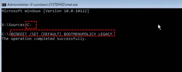 解决kernel_security_check_failure蓝屏的17种方法Feb 12, 2024 pm 08:51 PM
Kernelsecuritycheckfailure(内核检查失败)就是一个比较常见的停止代码类型,可蓝屏错误出现不管是什么原因都让很多的有用户们十分的苦恼,下面就让本站来为用户们来仔细的介绍一下17种解决方法吧。kernel_security_check_failure蓝屏的17种解决方法方法1:移除全部外部设备当您使用的任何外部设备与您的Windows版本不兼容时,则可能会发生Kernelsecuritycheckfailure蓝屏错误。为此,您需要在尝试重新启动计算机之前拔下全部外部设备。
 如何在 Windows 11 或 10 上安装 GitHub Desktop?May 25, 2023 pm 03:51 PM
第1步:下载GitHubDesktop不想使用命令行安装GitHubDesktop的可以到官网手动下载。访问链接,使用“为Windows64位下载”按钮获取系统上的可执行安装文件。单击它时,将出现一个弹出窗口以保存GitHubDesktopSetup-x64.exe文件。第2步:在Windows11或10上安装GitHubDesktop完成下载过程后,安装文件将在您的系统上。双击它以启动GitHubDesktop的安装过程。稍等几秒,系统很快就会自动
 System76 tips Fedora Cosmic spin for 2025 release with Fedora 42Aug 01, 2024 pm 09:54 PM
System76 has made waves recently with its Cosmic desktop environment, which is slated to launch with the next major alpha build of Pop!_OS on August 8. However, a recent post on X by System76 CEO, Carl Richell, has tipped that the Cosmic DE developer
 CAMM2 for desktop PCs: MSI explains the benefits of the new RAM standard for gaming towersAug 17, 2024 pm 06:47 PM
The first LPCAMM2 modules for laptops are already being delivered, and desktop mainboards are also expected to be equipped with CAMM2 in future. CAMM2 and LPCAMM2 are not compatible with each other, and even on desktop PCs, customers need to be caref
 desktop是什么文件夹Feb 01, 2023 pm 04:02 PM
desktop是桌面文件夹,查看desktop文件夹的方法是:1、打开桌面上的“我的电脑”;2、点击打开C盘;3、再点击页面右上角的搜索框;4、输入“桌面”搜索,在搜索结果中即可看到“桌面”文件夹。
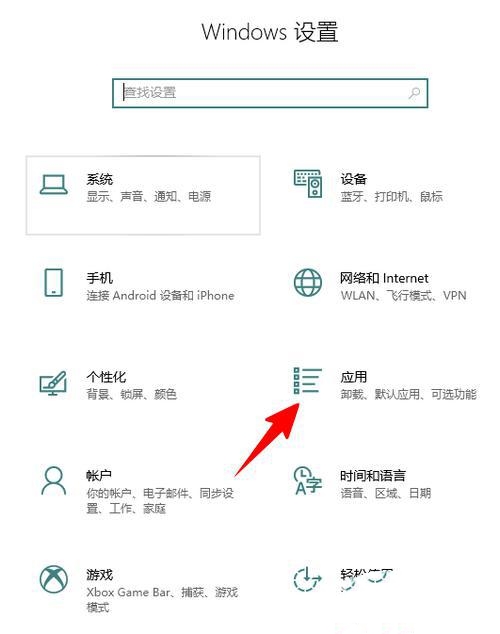 Win10如何卸载Skype for Business?电脑上的skype怎么彻底卸载方法Feb 13, 2024 pm 12:30 PM
Win10skype可以卸载吗是很多用户们都想知道的一个问题,因为很多的用户们发现自己电脑上的默认程序上有这个应用,担心删除后会影响到系统的运行,下面就让本站来为用户们来仔细的介绍一下Win10如何卸载SkypeforBusiness吧。Win10如何卸载SkypeforBusiness1、在电脑桌面点击Windows图标,再点击设置图标进入。2、点击“应用”。3、在搜索框中输入“Skype”,点击选中找到的结果。4、点击“卸载”。5
 JavaScript怎么用for求n的阶乘Dec 08, 2021 pm 06:04 PM
用for求n阶乘的方法:1、使用“for (var i=1;i<=n;i++){}”语句控制循环遍历范围为“1~n”;2、循环体中,使用“cj*=i”将1到n的数相乘,乘积赋值给变量cj;3、循环结束后,变量cj的值就n的阶乘,输出即可。
 desktop是什么型电脑Jun 24, 2021 pm 04:09 PM
desktop的中文意思为“桌面”,因而desktop电脑指代桌上型电脑,即台式机电脑,它的主机、显示器等设备一般都是相对独立的,一般需要放置在电脑桌或者专门的工作台上。


熱AI工具

Undresser.AI Undress
人工智慧驅動的應用程序,用於創建逼真的裸體照片

AI Clothes Remover
用於從照片中去除衣服的線上人工智慧工具。

Undress AI Tool
免費脫衣圖片

Clothoff.io
AI脫衣器

AI Hentai Generator
免費產生 AI 無盡。

熱門文章
熱工具

禪工作室 13.0.1
強大的PHP整合開發環境

Atom編輯器mac版下載
最受歡迎的的開源編輯器

ZendStudio 13.5.1 Mac
強大的PHP整合開發環境

SublimeText3 Mac版
神級程式碼編輯軟體(SublimeText3)

Dreamweaver Mac版
視覺化網頁開發工具

