Home >Software Tutorial >Computer Software >How to export images from Bigemap GIS Office in just a few steps
How to export images from Bigemap GIS Office in just a few steps
- 王林forward
- 2024-02-13 16:00:24716browse
php editor Xinyi will introduce to you how to export pictures in Bigemap GIS Office. Bigemap GIS Office is a powerful geographic information system software that can help users perform map production and spatial analysis. When you need to export your map to image format, you can do it in just a few simple steps. First, select the map layer you want to export in Bigemap GIS Office, then click the export button, select the image format in the pop-up export settings, and finally click Confirm to export. With a few simple steps like this, you can quickly and easily export the map as a picture for easy saving and sharing.
[Export method]
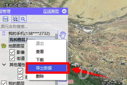
1. First, click [Layer Management], select the layer you want to export, and right-click the menu to select [Export Data].

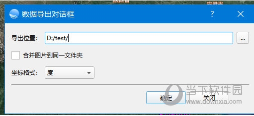
2. Then set the export location, uncheck Merge pictures into the same folder, default and confirm

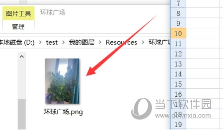
3. Then go to the previously set folder, and you can see that it contains the longitude and latitude coordinates, names, and key pictures of all points. At the same time, the pictures are saved separately according to the point names, and there is no need to manually classify them.

The above is the detailed content of How to export images from Bigemap GIS Office in just a few steps. For more information, please follow other related articles on the PHP Chinese website!

