
 Technology peripheralsAIAlibaba DAMO Academy releases the industry's first large-scale remote sensing AI model, claiming to be able to identify nearly 100 types of land object classifications
News on October 20, according to the official public account of DAMO Academy, Alibaba DAMO Academy today released the industry's first remote sensing AI large model (AIE-SEG) , claiming to be "the first in remote sensing The field realizes the unification of image segmentation tasks" and "one model realizes the rapid extraction of 'zero samples of all things'", and can identify nearly a hundred types of remote sensing land objects such as farmland, water, and buildings, and can also classify them based on the user's interactive feedback. Automatically tune recognition results.
It is reported that remote sensing technology is mainly used in urban planning, farmland protection, emergency disaster relief and other industry applications. With the support of AI, relevant remote sensing technology can analyze satellite capture content and historical meteorological data, thereby assisting urban operations. , farmland protection, emergency disaster relief and other industry applications.
This site summarizes the features of this large remote sensing model as follows:
- Supports multi-modal interaction. For example, if you enter "Extract farmland from the image", it will automatically identify all the fields. Select target

- ## Supports any surface target recognition and establishes multi-level semantic labels System
 ▲ Picture source DAMO official public account
- supports satellites and unmanned aerial vehicles Extraction of all elements of machine images
##▲ Picture source DAMO official public account 
- Support Interactive result correction, such as mistakenly extracting "water areas" when identifying "paddy fields", can be corrected through manual operations
▲ Picture source DAMO official Public account 
- supports general and multi-category change detection
▲ Picture source DAMO official The public account 
Damo Academy also claimed that this large remote sensing AI model provides "out-of-the-box" API calling services, and users can customize different remote sensing AI interpretation functions according to their needs. Such as "water extraction", "cultivated land change monitoring", "photovoltaic identification", etc.
This will allow AI to further penetrate into the fields, greatly improving the analysis efficiency of remote sensing applications such as disaster prevention, natural resource management, and agricultural yield estimation.
At present, this AI model has been applied in the industry. For example, the Shandong Provincial Land Surveying and Mapping Institute and Alibaba Damo Institute cooperated to use a remote sensing AI large model to monitor the growth of winter wheat, with a recognition accuracy of 90% % or more, effectively improving the efficiency of winter wheat remote sensing interpretation, helping agricultural managers better predict grain yield and improve agricultural production efficiency.
The National Institute of Natural Disaster Prevention and Control also uses this model to identify landslides and collapsed buildings. In the test of remote sensing images of historical natural disaster areas, it only takes ten minutes. It can extract disaster information, which is dozens of times more efficient than manual identification, providing efficient and accurate remote sensing analysis support for scientific disaster relief.
The above is the detailed content of Alibaba DAMO Academy releases the industry's first large-scale remote sensing AI model, claiming to be able to identify nearly 100 types of land object classifications. For more information, please follow other related articles on the PHP Chinese website!

 I Tried Vibe Coding with Cursor AI and It's Amazing!Mar 20, 2025 pm 03:34 PM
Vibe coding is reshaping the world of software development by letting us create applications using natural language instead of endless lines of code. Inspired by visionaries like Andrej Karpathy, this innovative approach lets dev
 How to Use DALL-E 3: Tips, Examples, and FeaturesMar 09, 2025 pm 01:00 PM
DALL-E 3: A Generative AI Image Creation Tool Generative AI is revolutionizing content creation, and DALL-E 3, OpenAI's latest image generation model, is at the forefront. Released in October 2023, it builds upon its predecessors, DALL-E and DALL-E 2
 Top 5 GenAI Launches of February 2025: GPT-4.5, Grok-3 & More!Mar 22, 2025 am 10:58 AM
February 2025 has been yet another game-changing month for generative AI, bringing us some of the most anticipated model upgrades and groundbreaking new features. From xAI’s Grok 3 and Anthropic’s Claude 3.7 Sonnet, to OpenAI’s G
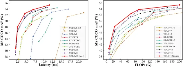 How to Use YOLO v12 for Object Detection?Mar 22, 2025 am 11:07 AM
YOLO (You Only Look Once) has been a leading real-time object detection framework, with each iteration improving upon the previous versions. The latest version YOLO v12 introduces advancements that significantly enhance accuracy
 Elon Musk & Sam Altman Clash over $500 Billion Stargate ProjectMar 08, 2025 am 11:15 AM
The $500 billion Stargate AI project, backed by tech giants like OpenAI, SoftBank, Oracle, and Nvidia, and supported by the U.S. government, aims to solidify American AI leadership. This ambitious undertaking promises a future shaped by AI advanceme
 Sora vs Veo 2: Which One Creates More Realistic Videos?Mar 10, 2025 pm 12:22 PM
Google's Veo 2 and OpenAI's Sora: Which AI video generator reigns supreme? Both platforms generate impressive AI videos, but their strengths lie in different areas. This comparison, using various prompts, reveals which tool best suits your needs. T
 Google's GenCast: Weather Forecasting With GenCast Mini DemoMar 16, 2025 pm 01:46 PM
Google DeepMind's GenCast: A Revolutionary AI for Weather Forecasting Weather forecasting has undergone a dramatic transformation, moving from rudimentary observations to sophisticated AI-powered predictions. Google DeepMind's GenCast, a groundbreak
 Which AI is better than ChatGPT?Mar 18, 2025 pm 06:05 PM
The article discusses AI models surpassing ChatGPT, like LaMDA, LLaMA, and Grok, highlighting their advantages in accuracy, understanding, and industry impact.(159 characters)


Hot AI Tools

Undresser.AI Undress
AI-powered app for creating realistic nude photos

AI Clothes Remover
Online AI tool for removing clothes from photos.

Undress AI Tool
Undress images for free

Clothoff.io
AI clothes remover

AI Hentai Generator
Generate AI Hentai for free.

Hot Article
Hot Tools

SublimeText3 Chinese version
Chinese version, very easy to use

SublimeText3 English version
Recommended: Win version, supports code prompts!

MantisBT
Mantis is an easy-to-deploy web-based defect tracking tool designed to aid in product defect tracking. It requires PHP, MySQL and a web server. Check out our demo and hosting services.

Dreamweaver CS6
Visual web development tools

WebStorm Mac version
Useful JavaScript development tools

