







环境
MySQL5.6
https://dev.mysql.com/doc/refman/5.6/en/spatial-relation-functions-object-shapes.html#function_st-distance
表结构及数据
DROP TABLE IF EXISTS `locationpoint`;
CREATE TABLE `locationpoint`
(
    `id`        int(11)       NOT NULL AUTO_INCREMENT,
    `province`  varchar(20)   NOT NULL,
    `city`      varchar(20)   NOT NULL,
    `longitude` double(10, 3) NOT NULL,
    `latitude`  double(10, 3) NOT NULL,
    PRIMARY KEY (`id`)
) ENGINE = InnoDB
  AUTO_INCREMENT = 1156
  DEFAULT CHARSET = utf8;
INSERT INTO `locationpoint`
VALUES (1, '山东', '济南', 116.938477, 36.597889),
       (2, '河北', '石家庄', 114.477539, 38.030786),
       (3, '浙江', '杭州', 120.058594, 30.334954),
       (4, '河南', '郑州', 113.629, 34.744),
       (5, '安徽省', '合肥', 117.170, 31.520);
查询方式
(以内蒙古自治区呼和浩特市为计算中心)

win可用的mysql指令skill
下载
安装、修复、更新或打包一个基于 Python 和 PyMySQL 实现的 Windows `mysql` 命令。适用于用户希望在 PowerShell/CMD 中输入 `mysql` 时重定向到 Python 实现、需要交互式输入 MySQL 连接信息、需要同步到当前用户本地 bin 目录,或需要将该能力封装成可公开复用的 Codex skill。
SELECT id,
       city,
       longitude,
       latitude,
       round(
                   (
                           st_distance(
                                   point(longitude, latitude),
                                   point(111.621094, 40.913513)
                               ) / 0.0111
                       ) * 1000
           )
           AS distance
FROM locationpoint
ORDER BY distance;
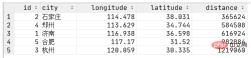
查询结果
推荐:《mysql教程》