Home >Backend Development >PHP Tutorial >PHP uses Amap (1) to draw polygons and edit to obtain coordinates (simple summary)
PHP uses Amap (1) to draw polygons and edit to obtain coordinates (simple summary)
- 不言Original
- 2018-04-19 13:27:313757browse
The content of this article is about using Amap with PHP (1) to draw polygons and edit to obtain coordinates (simple summary). It has certain reference value. Now I share it with you. Friends in need can refer to it. Let’s take a look
If you use the Amap API for the first time, you must first apply for a Amap key
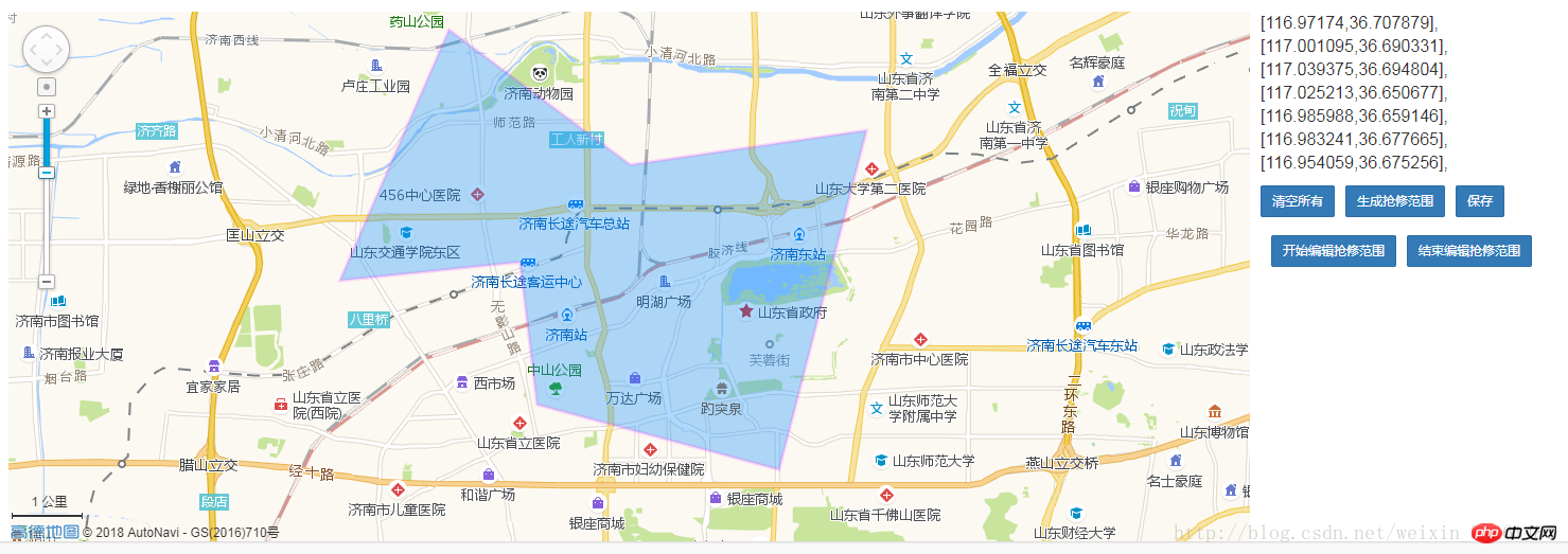
Main instructions:
1. Amap map display
2. Amap map Click to get the coordinates
3. Draw polygons with the mouse on Amap
4. Edit polygons with the mouse on Amap and get the coordinates
<style>
    .map-list{float: left; margin-left: 10px;}
    .pbot10{ padding-bottom: 10px;}
    .marleft{ margin-left: 10px;}
    </style>
    <p class="panel panel-default">
        <p class="panel-body">
        <p>
        <p id="container" style="width: 70%; height: 500px; float: left;"></p>
        <p style="margin-bottom: 5px;">
        <ul class="map-list-add">
        <?php
        foreach ($oldRegionArr as $k => $v):
        ?>
        <li>
        [<?=$v;?>],
        </li>
        <?php endforeach;?>
        </ul>
        <ul class="map-list-hidden hidden">
        <?php foreach ($oldLngLatArr as $key => $val):?>
        <li>
        <?php foreach ($val as $k => $v):?>
        <span><?=$v;?></span>
        <?php endforeach;?>
        </li>
        <?php endforeach;?>
        </ul>
        <textarea class="form-control hidden" name="region" rows="3">
        </textarea>
        </p>
        <a class="btn btn-primary btn-sm fl" id="clearMarker" onclick="clearMap()">清空所有
        </a>
        <a class="btn btn-primary btn-sm fl marleft" id="huaMarker">生成抢修范围
        </a>
        <br><br>
        <a class="btn btn-primary btn-sm fl marleft" id="PolyEditor" onClick="startEditPolygon()">开始编辑抢修范围
        </a>
        <a class="btn btn-primary btn-sm fl marleft" id="CircleEditor" onClick="closeEditPolygon()">结束编辑抢修范围
        </a>
        </p>
        </p>
        </p>
        </p>
        </p>
        <script type="text/javascript" src="http://webapi.amap.com/maps?v=1.4.4&key=高德key&plugin=AMap.MouseTool,AMap.PolyEditor,AMap.CircleEditor">
        </script>
        <script type="text/javascript">
        var city  = '济南';
        //生成地图
        var map = new AMap.Map('container',{
        resizeEnable: true,        zoom: 13
        });
        //地图上添加工具
        AMap.plugin(['AMap.ToolBar','AMap.Scale','AMap.OverView'],
        function() {
            map.addControl(new AMap.ToolBar());
            map.addControl(new AMap.Scale());
            });
            //设置地图中心
            var lngLat = map.getCenter();
            var lng = lngLat.lng;
            var lat = lngLat.lat;
            if(city) {
        map.setCity("" + city + "");
        } else {
        map.setCenter([lng, lat]);
        }
        //清空地图
        function clearMap()
        {
        map.clearMap();
        $('.map-list-add').html('');
        positions = [];
        $('textarea[name=region]').val('');
        $('.map-list-hidden').html('');
        }
        //点击地图获取坐标
        function huaNew()
        {
        var positions = [];
        //地图上点击事件
        map.on('click', function(e)
         {
         //显示点击的坐标
         var lngLat = e.lnglat.getLng() + ',' + e.lnglat.getLat();
         //将坐标填的 ul
         var html = $('.map-list-add').html();
         html += '<li>[' + lngLat + ']</li>';
         positions.push([e.lnglat.getLng(), e.lnglat.getLat()]);
         $('.map-list-add').html(html);
         });
         }
         //画多边形的参数
         var xian = {
         strokeColor: "#FF33FF", //线颜色
         strokeOpacity: 0.2, //线透明度
         strokeWeight: 3,    //线宽
         fillColor: "#1791fc", //填充色
         fillOpacity: 0.35//填充透明度
         };
         //画多边形
         var mouseTool = new AMap.MouseTool(map);
         //在地图中添加MouseTool插件
         AMap.event.addDomListener(document.getElementById('huaMarker'), 'click', function()
          {
          clearMap();
          huaNew();
          mouseTool.polygon(xian);
          }, false);
          //默认加载的多边形
          $(function ()
          {
          var markers = [], positions = [];
          var valRegion = '[116.97174,36.707879],[116.986675,36.681658],[116.983241,36.677665],[116.954059,36.675256],';
          var len = $('.map-list-hidden li').length;
          for(var p=0; p < len; p++) {
          var posit = [];
          var defaultLng = $('.map-list-hidden li:eq('+p+') span:eq(0)').html();
          var defaultLat = $('.map-list-hidden li:eq('+p+') span:eq(1)').html();
          posit.push(parseFloat(defaultLng));
          posit.push(parseFloat(defaultLat));
          positions.push(posit);
          }
          $('textarea[name=region]').val(valRegion);
          //编辑多边形
          var _polygon = (function(){
          var arr = positions;
          xian.path = positions;
          xian.map = map;
          return new AMap.Polygon(xian);
          })();
          //编辑多边形初始化
          _polygonEditor = new AMap.PolyEditor(map, _polygon);
          //开始编辑
          startEditPolygon = function(){
          _polygonEditor.open();
          }
          //结束编辑
          closeEditPolygon = function(){
          var html = '', htmlText = '';
          _polygonEditor.close();
          var a =  _polygon.getPath();
          for(var q = 0; q < a.length; q++) {
          var posit = [];
          posit.push(parseFloat(a[q]['lng']));
          posit.push(parseFloat(a[q]['lat']));
          html += "<li>[" + posit + "],</li>";
          htmlText += "[" + posit + "],";
          }
          $('.map-list-add').html(html);
          $('textarea[name=region]').val(htmlText);
          }
    });
    </script>

# #Reference:
##http://lbs.amap.com/api/javascript-api/guide/create-map/show-map Show maphttp: //lbs.amap.com/api/javascript-api/example/marker/marker-content Point mark example
http://lbs.amap.com/api/javascript- api/example/overlayers/polyline-circle-polygon Polyline, polygon, circle examples
##http://lbs.amap.com/faq/web/javascript-api/327
http://lbs.amap.com/api/javascript-api/example/overlayers/edit-polyline-circle-polygon Edit polyline, polygon, Circle
http://lbs.amap.com/faq/web/javascript-api/editpolygon-getpath
The above is the detailed content of PHP uses Amap (1) to draw polygons and edit to obtain coordinates (simple summary). For more information, please follow other related articles on the PHP Chinese website!

